Drone Photography for Real Estate in Vaudreuil-Soulanges: Rules, Costs and When It's Worth It
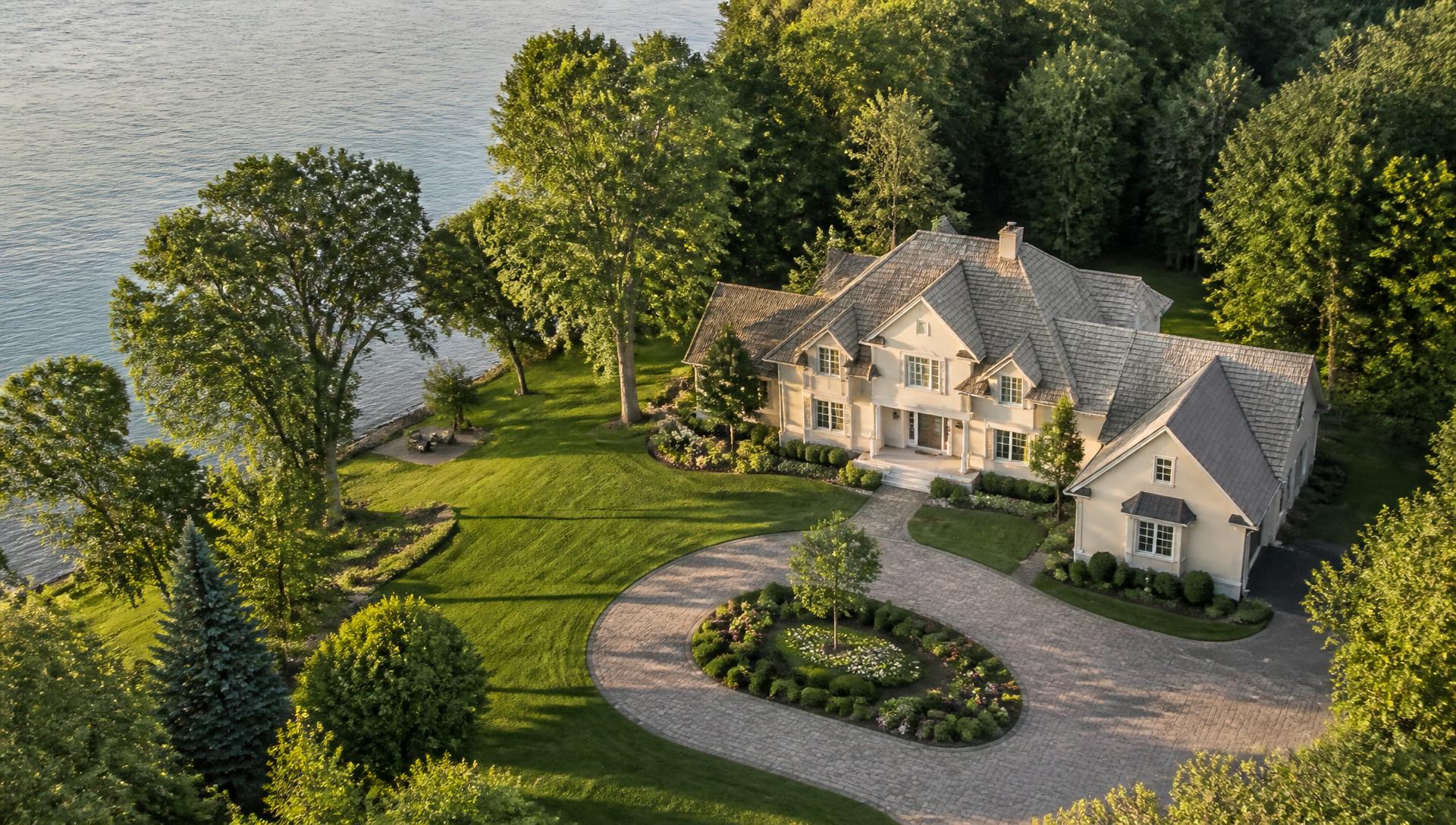
Stand on the shoreline in Hudson at sunset, or look across a five-acre horse property in Saint-Lazare, and you understand instantly what a ground-level camera can never capture: in Vaudreuil-Soulanges, the setting is often half the value of the home. Wedged between the Ottawa River and the St. Lawrence, our region sells space, water and sky — and that is exactly what drone photography was invented to show.
For sellers and brokers, that creates a practical question: when is an aerial shoot worth the money, what does it cost, and what are the rules? Here is the plain-language answer for our corner of Quebec, based on how the 2026 market actually behaves.
Vaudreuil-Soulanges Was Made for Aerial Photography
Few regions west of Montreal offer this much visual range within a 20-minute drive. Waterfront on Lac des Deux Montagnes in Hudson and Vaudreuil-sur-le-Lac. The beach community along Saint-Zotique's shoreline. Equestrian acreage in Saint-Lazare. Mature-tree streets in old Pincourt. And in Vaudreuil-Dorion, entire new neighbourhoods rising within sight of the water — a city whose average selling price hovered around $545,000 in early 2026, up roughly 15% year over year, with transaction volume climbing alongside it.
That growth is a double-edged sword for sellers. More buyers are coming — but more listings compete for their attention every month. When twenty comparable homes hit Centris in the same week, the one whose first photo shows a dock, a river and a glowing backyard stops the scroll. The one shot from the sidewalk gets a swipe.
What Aerial Shots Tell Buyers That Ground Photos Can't
A good drone session is not one dramatic photo. It is a short, deliberate shot list, and each angle answers a question buyers always ask next:
- The elevated hero: the facade photographed from 20 to 30 feet up — level, flattering, and already more cinematic than anything from the lawn
- The top-down lot view: the honest answer to "how big is the yard really?" — boundaries, pool, shed, patio and all
- The orbit video: a slow 360-degree circle around the property that shows roof condition, landscaping and layout in one motion
- The shoreline approach: for waterfront homes, a smooth flight in from the water — the shot that sells the lifestyle, not just the house
- The context shot: the marina down the road, the Soulanges Canal bike path, the commuter train station, quick access to Highways 20, 30 and 40 — the neighbourhood buyers are really buying into
Ground photography documents rooms. Aerial photography answers objections. Together they let a buyer arrive at the first visit already convinced.
The Legal Side: Transport Canada Rules in Plain Language
Here is what many sellers don't realize: the moment a drone is flown to help sell a property, it is a commercial operation under Canadian aviation law — recreational rules do not apply. A legitimate operator needs:
- A Transport Canada RPAS pilot certificate — and for most built-up areas, the advanced certificate, which covers flights near bystanders and in controlled airspace
- A registered drone with its registration number marked on the aircraft
- A site survey for the property before every flight, as the regulations require
- Airspace authorization where required — parts of the West Island and the corridor toward the airport fall under controlled airspace that must be cleared in advance
- Liability insurance — most brokerages now require proof before anyone flies over a listing
This matters to you even if you never touch a controller. If a friend "with a drone" films your listing and something goes wrong — a crash into a neighbour's car, a complaint to Transport Canada — the liability conversation gets uncomfortable fast. Hiring a certified, insured pilot is not a luxury; it is the baseline. Any professional you book should be able to show both credentials without hesitation.
When the Drone Add-On Is Worth It (and When It Isn't)
Honest answer: not every listing needs a drone. In our region, the aerial add-on earns its keep when the property's value extends beyond its walls:
- Waterfront and water-view homes — the single strongest case; the shoreline is the listing
- Large lots and acreage — properties in Saint-Lazare, Saint-Zotique and Les Cèdres where the land is measured in acres, not feet
- Corner lots and unique settings — mature trees in Hudson, cul-de-sacs in Pincourt, golf-course adjacency
- New and high-value construction — Vaudreuil-Dorion developments where buyers want to see the whole streetscape
Skip it for a mid-block townhouse with modest surroundings, or a condo whose view is the neighbour's wall. A trustworthy provider will tell you that up front.
The math is simple. Professional listing photos run $175 to $300, and a drone photography add-on typically adds $150 to $400. Industry analyses consistently find that listings with aerial imagery sell measurably faster than photo-only listings — and on a half-million-dollar home, shaving even one week of carrying costs off the sale pays for the shoot several times over.
How a Drone Shoot Actually Works
From the seller's side, the process is almost boring — which is exactly the point:
- You send the address. The operator checks the airspace and plans the flight before anyone commits
- Weather is watched. Wind, rain and low cloud ground drones; a professional reschedules at no charge rather than deliver grey, shaky footage
- Flight day is fast. Most residential shoots take 30 to 60 minutes on site, usually piggybacked on the photo session in a single visit
- Delivery is quick. Edited, colour-graded images and clips typically arrive within 48 to 72 hours, ready for Centris, MLS and social media
Timing helps too. In Quebec, late golden-hour light flatters waterfront homes; summer green flatters acreage; and the two peak weeks of October colour can make an ordinary street in Hudson look like a postcard. Sellers in Saint-Lazare and across the region increasingly plan their listing date around the shoot, not the other way around.
Thinking about aerials for your listing? Group PV Media flies Transport Canada certified, fully insured drone shoots across Vaudreuil-Soulanges and the West Island — bundled with professional listing photography in a single visit. Send us the address today and we'll confirm the airspace, quote the flight, and have your home looking its absolute best from every angle.
For the complete breakdown of real estate photography costs, prep, and add-ons in this market, see Real Estate Photography in Vaudreuil-Soulanges (2026). For Transport Canada certification requirements, typical drone add-on pricing, and non-real-estate uses like construction documentation, see Drone Photography for Quebec Real Estate & Business (2026).
Want to apply this to your business?
Book a free 30-minute call. We’ll look at your situation together and you’ll leave with a clear plan — no commitment.
Book a free consultation